Posts

Showing posts with the label Hydrographic Survey

Radiation Heat Transfer

Image
View Factor Orientation (or View factor or shape factor) plays an important role in radiation heat transfer. View factor is defined as, "fraction of radiation leaving surface 'i' and strike 'j' ". Summation Rule (View Factor) If there is are similar surfaces 'i' and 'j' , then: Blackbody Radiation Exchange Radiation Exchange between Opaque, Diffuse, Gray surfaces in an Enclosure 1. Opaque 2. Surfaces 3. Two surface enclosure Radiation Shield It is used to protect surfaces from radiation act like a reflective surface. References: Material from Class Lectures + Book named Fundamentals of Heat and Mass Transfer by Theodore L. Bergman + My knowledge.  Photoshoped pics  are developed.  Some pics and GIF from Google.   Videos from YouTube ( Engineering Sights ).

Advantages of Hydrographic Survey

Image
ADVANTAGES OF HYDROGRAPHIC SURVEY Accurate hydrographic survey and nautical charts yields many social benefits and contribute alot in making our life even more luxurious. 1.Safety of navigation is the single most important result of hydrography. This allows ships to safely travel in and out of ports, saving lives and property and protecting the environment.   2. National Security requires that navies successfully navigate coastal waterways. 3. Maritime commerce drives the global economy and depends on safety of navigation. 4. Humanitarian relief in the aftermath of a natural disaster frequently arrives on a ship. Until a clear and safe route to shore is established by hydrographers, supplies cannot reach those in need. 5. Environmental management in coastal areas depends on knowledge of changes in the marine environment. Hydrographic surveys determine changes to bathymetry and seafloor characteristics. 6. Commercial fishing uses nautical charts...

Bathymetric operation in Hydrographic Survey

Image
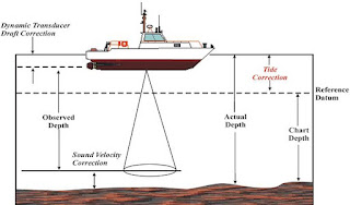
Hydrographic Survey Uses: It is used to determine mean sea level and observation of tides in oceans, lakes, Bayer and harbors. Used to find water depths and locations of rocks, sand bars for navigation channel opening and salvage operation. Determination of pollution sources.  For designing of projects like dams, bridges, reservoirs, port, harbors and many alot. Preparation of nautical charts(nautical chart is the graphical representation of a sea area and the adjacent coastal regions.  Through the knowledge of Hydrographic Survey we can prepare navigation charts. Objectives of Hydrographic Survey Measurements of wavelengths of tides and waves. Construction of sea defence works.  Determination of bed depth. Location of underwater features.  Off shore engineering and shipping industries and many more things. Bathymetric operations in Hydrographic Survey  Hydrographic Echo Sounder: Hydrographic Echo Sounder is used to find the d...

Techniques and instruments used in Hydrographic Survey

Image
Hydrographic Survey Hydrography is the science which determines the physical features and the navigable portions of the Earth's surface adjoining coastal areas. Surveyors study bodies of water to see what the floor looks like. Techniques and Instruments used in Hydrographic Survey : Many instruments are used in hydrographic survey like multibeam sonars, LIDAR, multibeam echo sounders(MBES), global positioning system (GPS), laser scanners etc. Among these instruments some are discussed ahead which are mostly used. 1. Light Detection and Ranging: LIDAR is used to measure the elevation or the depths of water bodies by analyzing the reflection of laser light off an object or seafloor.  Bathymetric LIDAR is used to determine is used to determine the depths of water bodies by measuring the time delay between the pulse of transmission and its return signals. 2.Multibeam Sonars: Multibeam echo sounders(MBES) or sonar systems transmit sound energy which strike seafloor a...

Hydrographic survey

HYDROGRAPHIC SURVEY   Hydrographic survey is an art or technique of determining the depth of water bodies( lakes, rivers, sea ports, and oceans, etc.; that is called Bathymetry. You can know the hidden features under the water surface by the knowledge of hydrographic survey. By the detailed knowledge of hydrography and bathymetry, these biggest industries such as oil refineries, ports, shoreline offices for different purposes, etc. References: Combined project on Hydrographic Survey by Taha Nasir, Rameez, Anas & Talha Shafique.